|
|
Useful Stuff
|
|
Sterling Section members can use this area to post information that would be useful for each other.
If you have any information you would like to post, drop us a line (trails@gmcsterling.org).
(Note: Print Friendly documents will open in a new window. They are "pdf" documents so you will need Adobe Acrobat Reader to look at them; which is free at www.adobe.com.)
|
PRINT READY SIGNS FOR USE AT TRAILHEADS:
|
LINKS to PDF's:
|
|
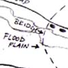
"Notice of High Water Route" - posted on approaches to the Lamoille River - locations south to north . . . 1.) jct West Settlement Rd and Lamoille Valley Rail Trail, bulletin board 2.) Rte 15 parking lot, bulletin board 3.) south of Lamoille River floodplain, sign board on tree 4.) north side of floodplain/south end of bridge over main channel of river, sign board on tree 5.) south side of Hogback Rd, sign board on tree.
|
|
|
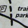
"Best Place to Park is Rte 15 Trailhead" - posted at Hogback Road . . . 1.) south side of Hogback Road, a little east of trail crossing, sign board on tree 2.) north side of Hogback Road, a little west of trail crossing, sign board on tree.
|
|
|
"Sterling Section introduction" - posted at the Rte 15 trailhead . . . 1.) at Rte 15 trailhead parking lot, bulletin board.
|

|
|
"Lamoille Valley Rail Trail introduction" - posted either end of the LVRT . . . 1.) jct West Settlement Rd and Lamoille Valley Rail Trail, bulletin board 2.) jct Lamoille Valley Rail Trail and path in meadow to north of rail trail, sign board on post.
|
|
|
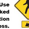
"Caution: High Speed Road Crossing." - posted either side of Rte 15 crossing . . . 1.) LT sign post immediately south of road 2.) bulletin board next to parking lot north of Rte 15.
|
|
|
DESCRIPTIONS OF PARTICULAR MAINTENANCE JOBS:
|
LINKS:
|
|
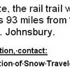
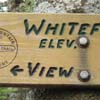
"Inventory of Routed Trail Signs". Pop Quiz - next time you hike the Section, make a note of all the signs that AREN'T there . . . wait, how would you know? Here is an inventory of signs that ought to be on the trail. This list is evolving. Contact us if you see a need for replacement signs, or have ideas about different signs. [NOTE: The linked document is print friendly, but it is a large file, 1,308 KB, and may take a few seconds to open.]
|
|
|
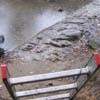
What's up with the Lamoille "back channel"? Each spring when the Lamoille River floods, it dramatically reshapes the southern bank where the Long Trail crosses the "back channel". This means that later each spring, after the water recedes, Section members should plan on reestablishing a blazed trail route through the back channel area.
|
|
|
|